Advanced…
Browse by Subject Category—Maps
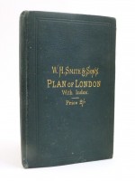
W. H. Smith's & Son's Plan of London with Index, c1875
A large fold-out coloured map of Victorian London
John Bartholomew
W H Smith & Son, London, 1875
On Hold
Maps | Hard Cover
About Cox & Budge
How To Buy
Shipping
Terms & Conditions
Privacy Policy
Contact Us
Popular Categories
Architecture & Design
Art
Autobiography & Biography
Drama
Fiction
Film & Theatre
Genealogy
Heritage Press
History
Maria Callas
Military & War
Music
Mythology, Customs & Folklore
Paranormal, Supernatural & Occult
Poetry
Topography & Local Interest
Travel & Exploration
William Shakespeare
More Categories
…
Recently Added
…
Browse by Date
Up to 1799
1800–1849
1850–1899
1900–1949
1950–
Attributes
Signed Copies
First Editions
Limited Editions
Fine Bindings
Leather Bound
Handwritten
Dustwrapper
Association Copy
Uncorrected proof
Hand-painted
First thus
Mixed Editions
Slipcase
Early printed music
Browse by
Subject
Author
Publisher